Near–real-time satellite imagery pipelines ingesting and processing data from NASA and ESA.
Data lake layer centralizes and scales multi-source geospatial data.
Data storage layer provides secure and governed client context.
Spatial intelligence through pattern recognition, prediction, and automated decision support.
The geospatial intelligence platform for climate intelligence ingests near–real-time satellite and environmental data from trusted global sources such as NASA and ESA and transforms it into actionable insights. It supports key use cases including air pollution management, land-use and land-cover classification, land surface and ambient temperature hotspot analysis, and vegetation cover indices. The platform enables time-series and change-detection mapping, on-demand access to historical data, and early-warning systems based on predefined thresholds—allowing users to track trends, detect anomalies, and respond proactively to climate and environmental risks.
The platform ingests multi-layered data comprising near–real-time satellite imagery, climate and weather variables (such as temperature, air quality, and vegetation metrics), and optional, securely governed client-specific datasets. These inputs are processed through scalable data pipelines that support continuous ingestion as well as access to historical archives, enabling robust spatial and temporal analysis.
AI-driven geospatial models convert these inputs into actionable outputs, including air quality insights, land-use and land-cover maps, temperature hotspot analyses, and vegetation indices. Results are delivered through interactive maps, time-series and change-detection visualizations, comparative analyses across dates or regions, and automated alerts triggered by predefined thresholds—supporting informed decision-making, risk mitigation, and climate-resilient planning.
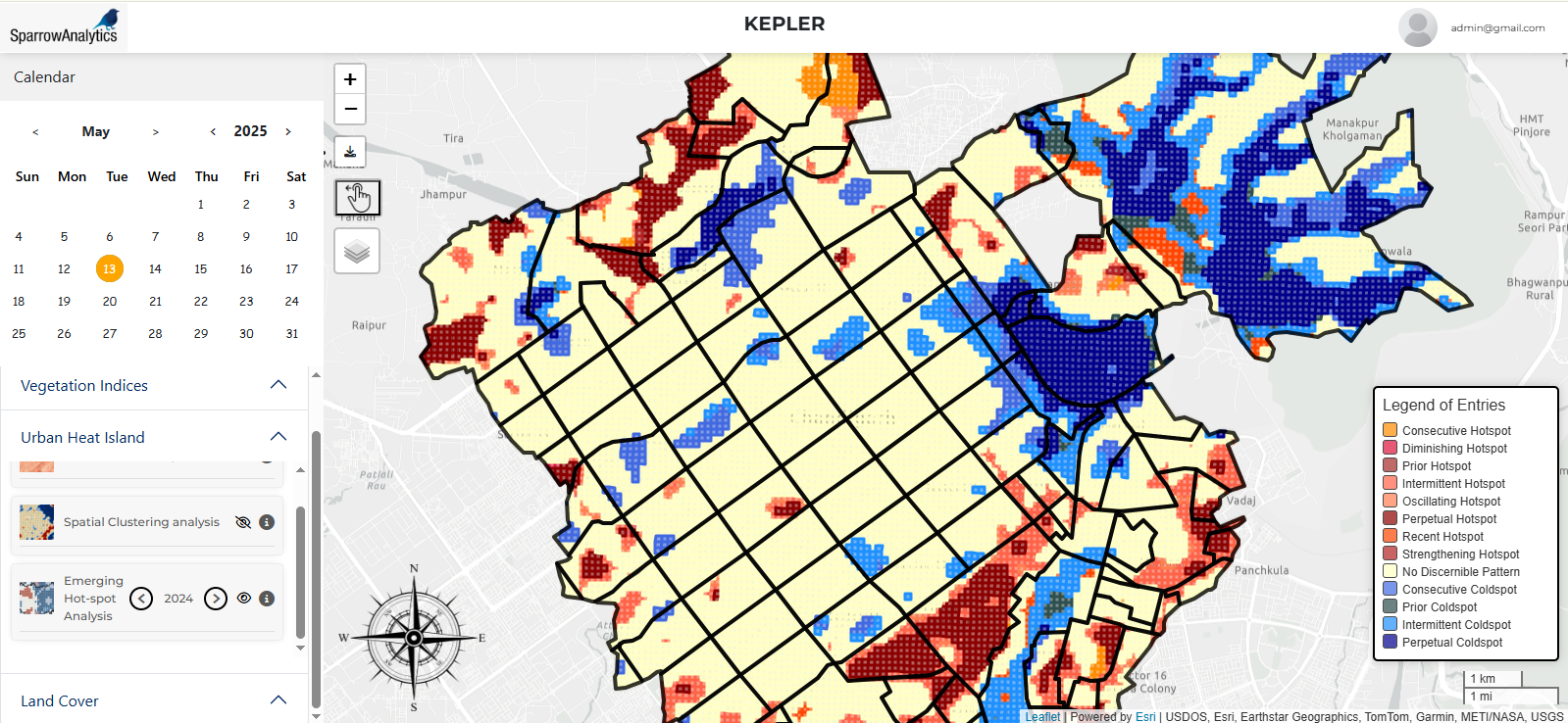
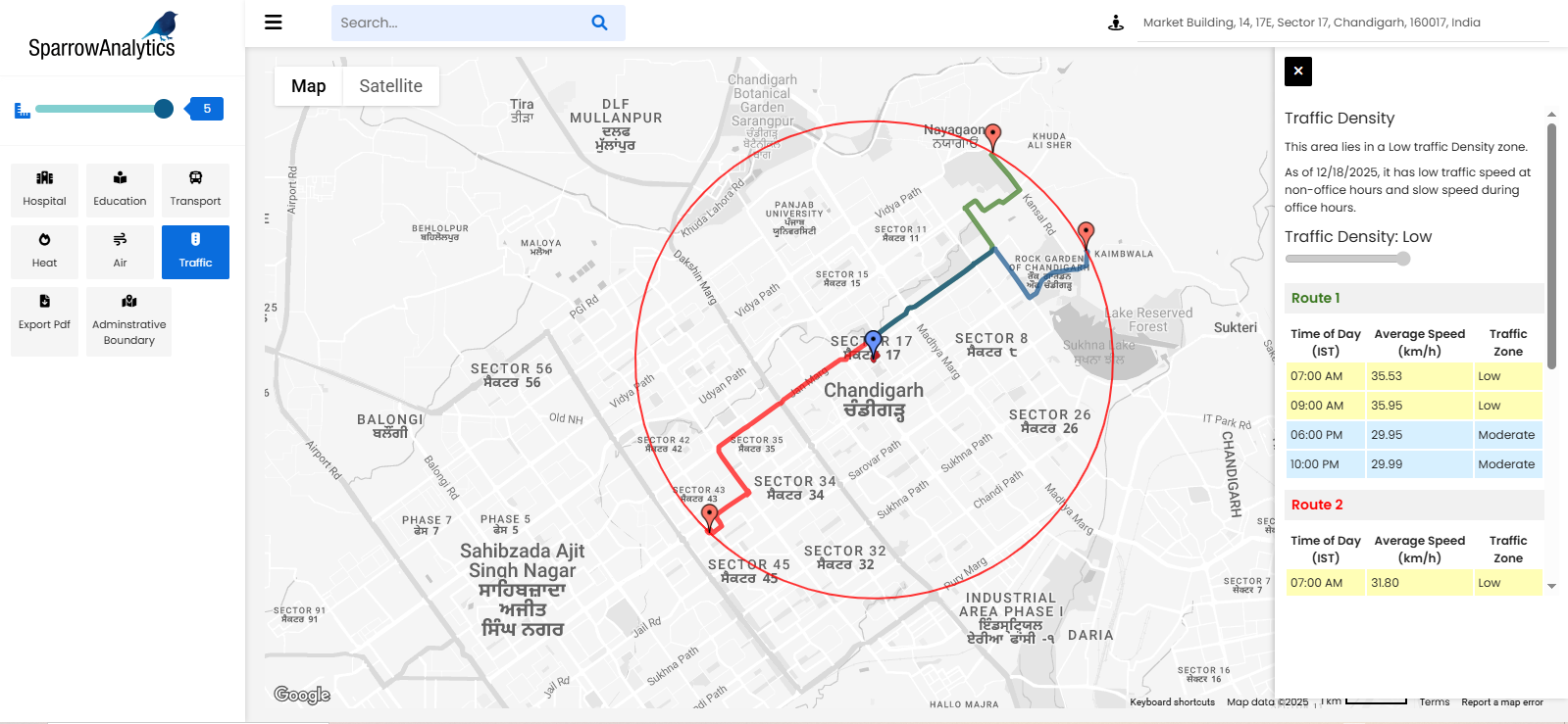
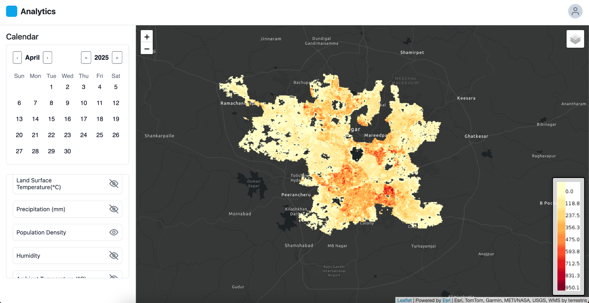
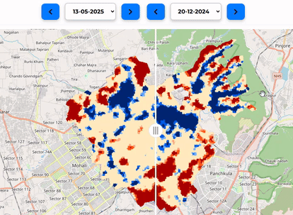
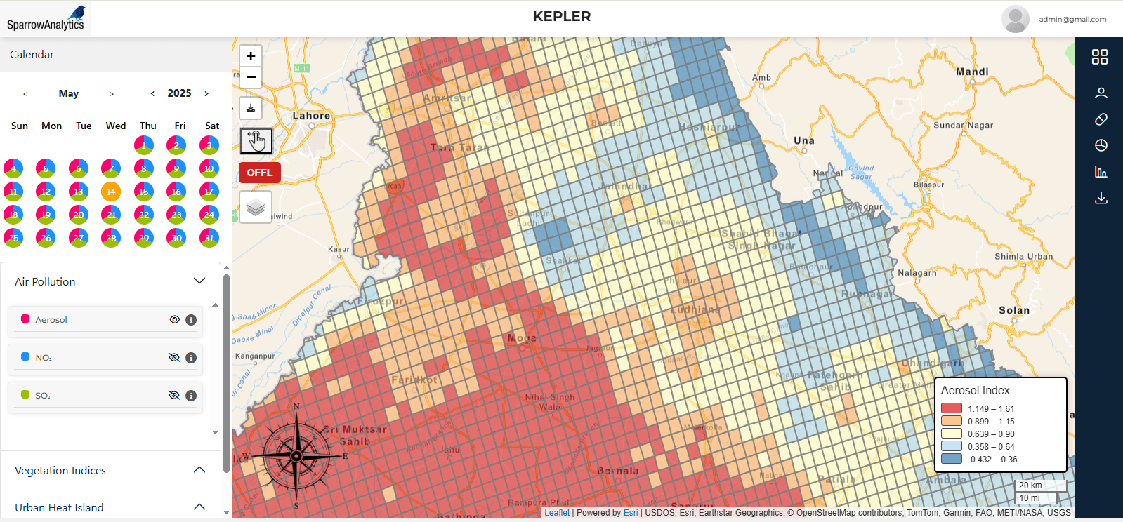
The location intelligence platform for real estate projects integrates multi-source geospatial and urban data to support smarter site selection, planning, and risk assessment. By combining satellite, mobility, and urban infrastructure data, the platform delivers contextual insights around environmental quality, accessibility, and livability—helping developers, investors, and planners evaluate locations beyond traditional market metrics.
The platform ingests diverse spatial datasets, including satellite imagery, air quality and environmental data, traffic and mobility patterns by time of day, urban infrastructure layers (such as roads, schools, hospitals, and public services), and optional client-specific project data. These inputs are processed through scalable pipelines that support both real-time and historical analysis, enabling fine-grained spatial and temporal understanding of each project location.
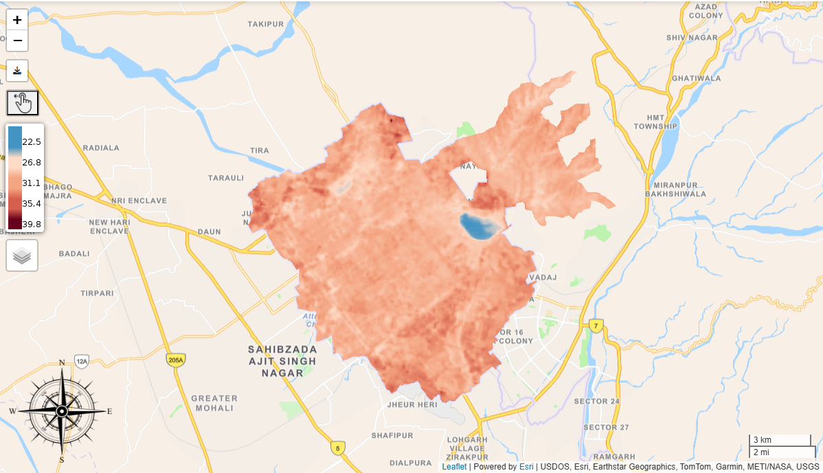
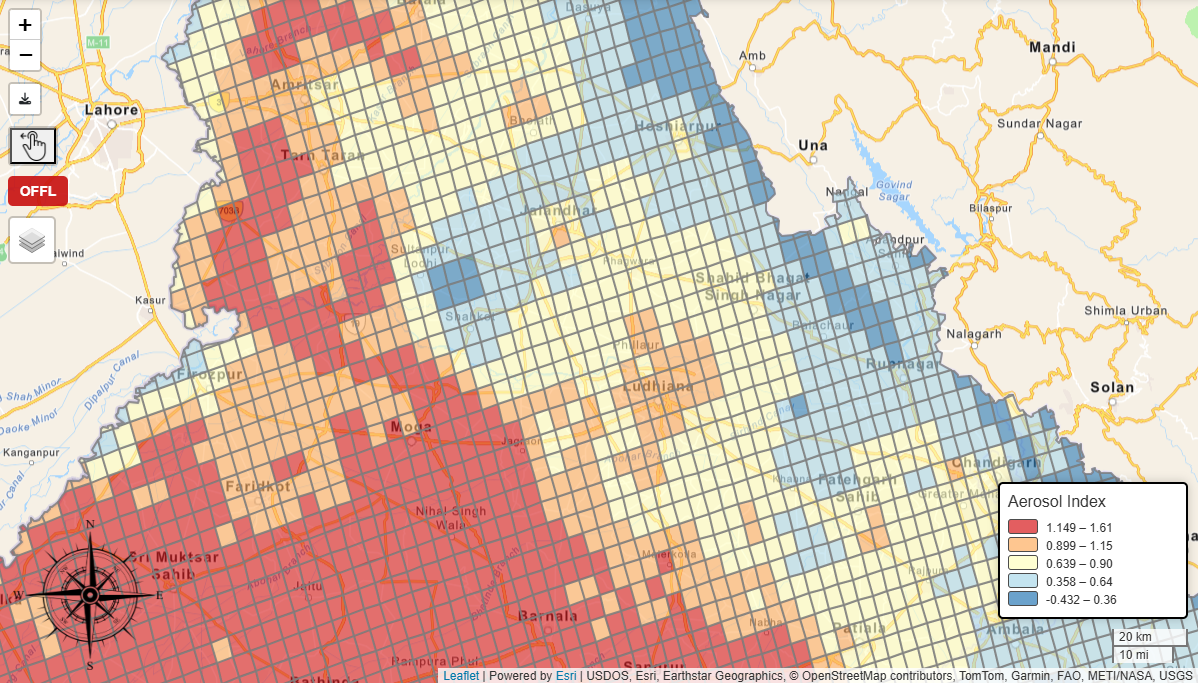
AI-driven location intelligence models generate actionable outputs such as identification of air pollution pockets around project sites, traffic density and congestion patterns segmented by time of day, proximity and accessibility analysis to schools and hospitals, and urban heat maps highlighting thermal stress zones. Outputs are delivered through interactive maps, comparative location scorecards, time-based visualizations, and risk or suitability indicators—empowering real estate stakeholders to make informed decisions on site viability, design optimization, and long-term asset value.
The location intelligence platform for public health projects integrates geospatial, environmental, and demographic data to support disease surveillance, prevention, and targeted interventions. By combining satellite-derived climate signals with population and infrastructure context, the platform enables public health agencies to anticipate health risks, prioritize resources, and design data-driven response strategies.
The platform ingests multi-layered data including satellite imagery and environmental variables such as temperature, precipitation, humidity, and land surface conditions; hydrological indicators identifying water-logged and stagnant water areas; population density and settlement patterns; and optional health surveillance or program-specific datasets. These inputs are processed through scalable pipelines that support near–real-time monitoring as well as historical trend analysis to capture seasonal and long-term risk dynamics.
AI-driven location intelligence models generate disease risk maps that identify high-risk areas based on environmental suitability for disease transmission, vector growth potential, and proximity to human habitation. Outputs include heat- and climate-linked risk zones, precipitation- and humidity-based vulnerability layers, spatial overlays of water-logged areas and settlements, and composite risk scores. These insights are delivered through interactive maps, time-series and change-detection visualizations, and early-warning alerts—enabling proactive public health planning, targeted interventions, and efficient allocation of resources.